By Nicholas Brokaw
Disturbance and recovery are major drivers of ecosystem structure and function in the Luquillo Experimental Forest (LEF). Two striking features of disturbance in the LEF are the long history of natural hurricane disturbance and the recent history of drastic human disturbance. Other natural disturbances include landslides, treefalls, floods, and droughts. Human disturbances include clearing for pasture and crops, creation of coffee plantations, logging, road construction, and withdrawal of water from streams. The frequency and variety of this disturbance regime creates a landscape of patches differing according to how and when they were last disturbed. An important overall finding is that the forest recovers fairly quickly after natural disturbance, since local species are adapted to these natural events. By contrast, the impacts of human disturbance, which are novel and drastic events in evolutionary history, last longer.
Hurricanes
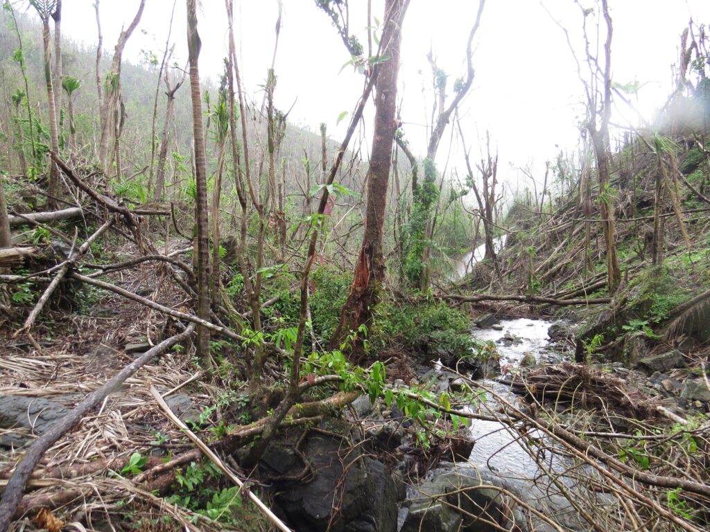
Since Luquillo LTER began in 1988, Hurricane Hugo severely affected the forest in 1989, Hurricane Georges struck in 1998, and Hurricane María struck in 2017. Preliminary data show that Hurricane María affected the forest more than the other two hurricanes; it felled and delimbed more trees and produced more open canopy than the other two storms. Despite the large amount of physical damage, recovery of forest structure, plant and animal populations, and ecosystem processes was fairly rapid (see Forest Dynamics).
Hurricane Hugo defoliated and delimbed many trees; 18-76% of trees were snapped off or uprooted, and about 17% of large trees were killed. Damage to the forest varied according to exposure, topography, and trees species composition. Sprouting of damaged trees, and recruitment of pioneer trees and shrubs responding to increased light, quickly began to restore forest structure. Despite the extensive damage, tree mortality was generally low enough that species composition changed little. Exceptions were some pioneer species, particularly the tree Cecropia schreberiana, which was abundant after the hurricane.
Animals in the tabonuco forest (see Setting and Food Web) were greatly affected by hurricane-caused changes in habitat structure and food resources. Frogs and snails that rely on litter for shelter or food increased. Nectar- and fruit-feeding birds declined, since flowers and fruits were destroyed, whereas insect-feeding birds increased, presumably in response to post-hurricane insect outbreaks. However, within about five years after Hurricane Hugo, most populations had returned to, or were approaching, pre-hurricane levels. Many animal species in the Luquillo Mountains tend to have broad adaptations, possibly in response to historically high levels of natural disturbance.
The heavy damage to the canopy by Hurricanes Hugo and Georges produced pulses of leaf litter and woody debris on the forest floor. After Hurricane Hugo, approximately 1 kg/m2 of litter was deposited on the forest floor and a like amount was suspended above the ground, which in total was equivalent to 1.2 times the annual litterfall. This hurricane litterfall had high concentrations of nitrogen and phosphorous. Nutrient losses were small, however, given the amount of damage and litterfall, because sprouting and nutrient uptake by fast-recruiting pioneer plants quickly restored aboveground nutrient pools and ecosystem function. Also, litterfall stimulated populations of microorganisms that captured nutrients and limited losses, but this also limited nutrient use by plants and so reduced short-term primary productivity.
After the hurricanes levels of nitrate and potassium were high in streams draining the Luquillo Mountains, but levels returned to normal within 1-2 years. High flows redistributed riparian detritus along the stream continuum, resulting in multi-year increases of detritivores such as freshwater shrimp.
Landslides
Landslides are most common at upper elevations in the Luquillo Mountains, but they often occur where road building has changed local slopes (see Landslides). Landslides are triggered by heavy rain storms, including hurricanes. They denude between 0.08 and 1.1% of the forest area per century. (Recent, numerous slides associated with Hurricane María may increase this estimate.) The pattern of loss and deposition of topsoil and detritus within a landslide strongly controls subsequent vegetation recovery. Vegetation on upper parts of landslides, with exposed mineral soils develops slowly in comparison to vegetation on lower parts, where topsoil and debris are deposited.
Treefall gaps
Individual treefalls, not caused by hurricanes, that create fairly discrete canopy gaps occur in the LEF, but these gaps are smaller and fewer than in many other tropical forests. This is because trees in the Luquillo Mountains are smaller (being trimmed every so often by hurricanes) than in some other tropical forests, and because many weak trees fall during hurricanes, leaving fewer to come down at other times. After a long hurricane-free period in the El Verde Research Area (just before Hurricane Hugo in 1989) treefall gaps were occurring at a rate of about 0.5 ha-1 year-1 and averaging 49.9 m2, compared to rates of about 1.0 ha-1 year-1 and 100 m2 per gap in other tropical forests. In the Bisley Experimental Watersheds treefalls are more frequent in wet valley bottoms than on ridges, where tabonuco (Dacryodes excelsa) trees are firmly rooted and connected by root grafts with each other. The tabonuco forest is a “hurricane forest”, its dynamics strongly controlled by exogenous hurricanes. This contrasts with forests not affected by hurricanes, where periodic, isolated treefalls have a more nearly continual and endogenous effect.
Human disturbance
Humans have disturbed the forests nearly everywhere in the LEF, except above about 670 m, where a few roads and buildings have been constructed. Between 670 and 600 m, on the western slopes of the mountains, there was a small amount of farming and some tree thinning until 50 years ago. Below 600 m, there has been more human use, including farming, logging, charcoal production, and coffee cultivation. All these uses ceased in about the 1930s when the LEF was acquired by the U.S. Forest Service (see Setting). Most of this zone within the LEF has been forested since the 1930s, with little human interference. But outside the boundaries of the Experimental Forest, on the lowest slopes of the mountains, there are today areas of pasture and early second growth.
The main effect of human disturbance is the removal of aboveground organic matter or its redistribution within the system, which usually leads to long-term or permanent impacts on forest structure and composition. For example, the Luquillo Forest Dynamics Plot in the El Verde Research Area (see Forest Dynamics) has been free of human disturbance for 70 years, but its tree species composition reflects past land use more strongly than damage from hurricanes in 1989 and 1998. In second-growth forests in the LEF tree biomass, species richness, and leaf decomposition processes can reach levels comparable to those in primary forest, but some primary forest tree species are lacking. Where forest has regrown in old coffee plantations there are high populations of leguminous trees planted for shade and high levels of soil N from these N-fixing species (Zimmerman et al. 1995a). In streams water diversions have large effects on organisms and ecosystem processes.
Interactions between disturbances
Disturbance effects are conditioned by previous, especially human, disturbances. Hurricanes Hugo and Georges were comparable in strength, but Hurricane Hugo felled and delimbed so many susceptible trees that Georges, coming nine years later, had much less impact. In the Forest Dynamics Plot, Hurricane Hugo caused most damage to trees in areas previously cleared, because the secondary tree species there were more susceptible to damage than were old-growth species. High rainfall associated with hurricanes initiates many landslides, which occur mainly where roads have changed local topography
Future
Several centuries ago, the highest elevations of the Luquillo Mountains became ecological islands of relatively intact forest in an otherwise agrarian landscape. In the last half century, the forest has re-grown at lower elevations, but suburbanization has advanced to the base of the mountain. The Luquillo Mountains now represent an island of well-established forest in a suburbanized setting. The dynamic landscape of Puerto Rico will continue to change. Organisms in the LEF seem to be well adapted to natural disturbances, but will they be able to cope with the changing land uses and changing climate, such as the predicted increase in frequency of droughts and strong hurricanes? As of 1989 severe hurricanes had passed over the LEF on average every 50-60 years in the past few centuries. But since then two more severe hurricanes have struck the forest.
Models suggest changes in the forest, with an increasing frequency of severe storms and of drought. The Luquillo LTER is positioned to help anticipate the effects of global change.